Trip Summary: March 1 - March 16, 2020
1) Flight to Denver, hiking at Golden Gate Canyon State Park
2) Hiking at Mt. Falcon Park and Genesee Park
3) Visiting research groups in Boulder
4) Rock climb 4-pitch, 5.8, 400 ft "Playin' Hooky" in Clear Creek Canyon near Denver
5) Downhill skiing at Breckenridge Ski Resort
6) Summit of Quandary Peak (14,265 ft)
7) Hiking, XC-skiing, and hanging out in Meeker
8) Mountain biking near Moab, Utah and hiking in Arches National Park
9) Canyoneering in Bighorn Canyon and Elephant Butte routes in Arches National Park
10) Hiking in Fiery Furnace in Arches National Park and flight out of Grand Junction
Alan, Cole, and I skiing at Breckenridge Ski Resort.
This was my first time visiting Colorado in the winter (albeit late winter, early spring), and it was a lot of fun. It was also my first time ever going to Utah and that state has a beauty all its own. I will definitely have to go back again, and would like to visit Canyonlands, Bryce Canyon, and Zion. This post is a little longer than some of my previous ones, since the trip itself was longer than usual (16 days) and the scenery was absolutely stunning (and I included more pictures).
Map of my trip to Colorado & Utah. Orange = train, violet = bus, blue = rental car, green = LeAnna's car, red = Alan's truck.
Visiting the Broncos Mile High Stadium with Ulises.
I was planning on presenting at the APS March Meeting in Denver during the first week but this was cancelled as soon as I arrived due to concerns about the novel coronavirus (COVID-19). I decided to make the most of my time in Denver to network with groups working on quantum computing before heading off to the hills to play with my friends Cole and Alan. I stayed with my friend Cole who had just recently moved to Denver for the first week before heading to Meeker to stay with Alan for the second week. By the time I flew home on March 16, COVID-19 was beginning to outbreak throughout the United States, including in Texas and Colorado. When I returned home, I immediately gathered my textbooks and lab notebooks from my office and self-isolated for the following week until stay-at-home orders were issued and a full-fledged pandemic was declared.
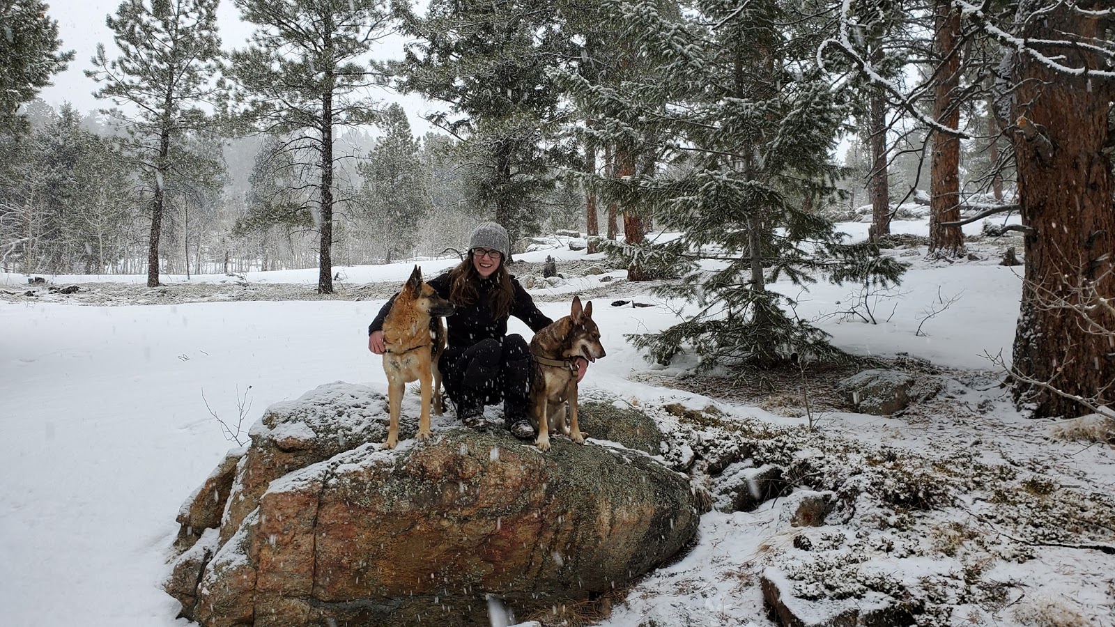
I flew into Denver early in the morning, and having found out the conference was cancelled shortly before taking off, I knew that I would have to make new plans for the week. I took the light rail into town and met up with my friend Ulises from Mexico. We took an Uber downtown for some breakfast at Illegal Pete's. We walked around downtown and visited the flagship REI before meeting up with my friend LeAnna. She had come down from Fort Collins to visit with her two dogs, and we all piled in her SUV and drove out into the mountains to explore Golden Gate Canyon State Park.
Golden Gate Canyon State Park - hiking near Denver, CO
LeAnna with her dogs at Golden Gate Canyon State Park.
It was Ulises's first time ever seeing snow, and snow started to fall during our drive there. We went hiking for about an hour before turning around, but during that time we caught each other up on the happenings in our lives, let the dogs frolic through the snow, and taught Ulises how to make a snow angel and throw snowballs. It was good-hearted fun. We drove back to Denver in time to meet up with Cole for dinner at Pizza Pedal'r. The next day I met up with Ulises for coffee at Huckleberry Roasters to send some emails in an attempt to network before taking a scooter ride to explore more of downtown.
Mt. Falcon Park and Genesee Park - hiking near Denver, CO
Hiking at Mt. Falcon Park with Ulises.
The next day, Ulises and I again spent the morning in the coffee shop to continue sending emails and sort out Ulises's return to Mexico. Realizing that Ulises was probably going to have to go back to Mexico early, and having invited him skiing the following weekend, I decided we should get back out into the mountains with his remaining time. I rented a car and we drove out to Mt. Falcon Park for some hiking. The views were beautiful, and I was glad we had made the trip as Ulises had to return to Mexico the next morning. We hiked about 4 miles, and the trails were easy and the windswept, snow-covered hills provided views of Denver to the east and the mountains to the west. We met up with Cole for dinner at Wynkoop Brewery and shared a sausage board - one made of elk and the other from rocky mountain oysters. I had the Artillery Ale while Cole had the Rocky Mountain Oyster Stout - both were good, but mine had less balls in the brewing process. I said goodbye to Ulises and we all went to bed.
Hiking at Genesee Park near Denver.
The next day I drove to Genesee Park which is just a little ways outside of Denver on I-70 as it enters the Front Range. I started at the Beaver Brook Trailhead and noticed a sign warning that traction was needed for this hike, and I hadn't brought my microspikes with me. I hiked for a little over an hour, intending to do the Beaver Brook - Chavez Trail Loop, but as the trail descended at an increasingly steep grade, I decided to turn around as I knew it would be difficult to climb back up on the icy trail. I made it back to the trailhead within an hour, and stopped by the bison viewing area before returning the rental car. That evening I met up for dinner at Euclid Hall with my friend Bryce who works in the field of quantum computing at Honeywell's ion trapping group.
Colorado University at Boulder and NIST - visiting physics groups in Boulder, CO
View of the Flatirons from JILA tower at UC Boulder.
On Thursday I left early in the morning for Union Station and took the Flatiron Flyer bus to Boulder. I met with a group at the Colorado University at Boulder campus about their research in nonlinear optics, high-harmonic generation, and ultrafast magnetic dynamics. I then visited the NIST Boulder campus and met several groups within the ion storage group, studying quantum computing and precision measurement of fundamental constants. After this, I returned to Denver and met up with Cole and Alan, who had arrived for a grant proposal earlier in the day. We had a little too much tequila that Ulises had brought up for me before having dinner at Ale House.
Playin' Hooky - 4-pitch, 5.8, 400 ft sport rock climb in Clear Creek Canyon near Denver, CO
Playin' Hooky route marked in red.
On Friday morning, Alan and I set out to do a multi-pitch rock climb and then meet up that evening in Dillon with Cole after he finished work. We planned on climbing The Young and the Rackless, a 3-pitch, 5.9, 300 ft sport climb near Boulder, but this was closed for raptor nesting. Instead we opted to climb Playin' Hooky, a 4-pitch, 5.8, 400 ft sport rock climb in Clear Creek Canyon near Denver.
We parked in the parking lot at the exit of Tunnel 5 and racked up our gear. A quick dash across the highway and a hop of the guardrail and we were on our way to the wall. After a little time spent finding the route, we arrived but another group was already climbing it. We waited for them to go up and I prepared to lead. We had cell phone reception, so we used our cell phones to communicate when the leader was out of sight and earshot of the belayer, and we devised backup rope signals. The climbing guide suggested combining the first two pitches into a single 200 ft pitch. We opted to do this, although I realized our 60 m rope was actually only 198 ft and it would be tight. The guide said 60 m ropes were sufficient, but I would add the comment that is true only when not combining P1-P2. Between the two of us, I had 14 quickdraws total with which to protect myself on this combo pitch.
Leading up P4 of Playin' Hooky.
The climbing was fun. There were blank, slabby sections which required precise footholds and finger crimps, along with several semi-dynamic moves. The climbing was relatively easy, but being much higher than any walls I climb in Texas, the exposure added another element. When I was about 30 ft away from the anchor, I got a phone call from Alan. He told me that I was almost out of rope and that I definitely didn't have 30 ft left. I told him I would continue climbing, and he should call again when I was out of rope and we would reassess the situation. I asked a climber on a route next to me about the sufficiency of 60 m ropes, and he said he thought you needed 70 m ropes in this area.
As I continued climbing, I came over a ledge and saw another set of anchor chains about 10 ft below the ones I had previously seen. I scrambled onto the ledge and clipped in, and set up to belay Alan. I gave him a phone call and told him to head up. When he arrived at the belay ledge, I asked him, "So I guess you had enough rope after all?" to which he replied, "No, I had to climb up about 15 feet to keep belaying you." Yikes.
Alan topping out the summit of Playin' Hooky.
The next pitch was relatively short, and I lead up a slight overhang and over a little traverse to the next belay ledge. I set up the anchor and Alan climbed up to me, before I set off on the final pitch. This pitch was steeper but the holds were juggy and solid, and I topped out pretty quickly. Alan climbed up to me and we took a few moments to appreciate the summit, but by now we were both ready to get back down as the wall was now shaded and it was cold and windy. Unfortunately, there was a lot of traffic on the route, and we had to wait for the guys who had climbed a nearby route to rappel. We rappelled next, but found that each rappel took considerable time. We had to wait for the group before us to rappel down, and position ourselves on the ledges with parties who were ascending. It was very crowded on the wall. At the P2 belay ledge, I was reunited with my jacket (which I had taken off earlier), but the final rappel was also a bit of a learning experience. Having almost no room on the belay ledge, and sharing it with another belayer, Alan was barely able to get a foothold on the wall and had to anchor in and basically hang in free space. I threw our rope down and it did not look like it reached the ground. The guys who descended before us yelled up "Your rope is short!" However, it looked close, and I reasoned that the rope would stretch some as I put my weight on it. Hopefully, it would be close enough to the ground that I could safely come off and scramble down. If not, my plan was to follow the bolt line and anchor in to the last bolt. We had knots at the ends of rope. As it was, I was just barely able to make it to the ground, and Alan quickly followed me. We exchanged pictures with the other guys before hiking back to the car. The route had taken us 4 hours total, but I think we spent more time going down than climbing. We drove to Alan's friend's house in Dillon and Cole met up with us later that night. I picked up some rental skis from REI for our ski outing the next day and Alan cooked up some delicious elk burgers for dinner.
Breckenridge Ski Resort - downhill skiing
Cole and I riding in the gondola.
After a hearty breakfast, we drove to the Airport Road shuttle bus parking lot and put on our ski gear. We took the shuttle to the gondola, and rode the gondola up to Peak 7 Station of Breckenridge Ski Resort. Alan had a free pass for me which had earned volunteering, and we took the Independence chairlift up towards Peak 7, and did a quick ski down Peak 6 Parkway to get to the Zendo chairlift and then to the Kensho chairlift up to Peak 6. This was my first time downhill skiing on proper mountain terrain - I have been skiing in Minnesota, but the ski hills are much smaller. We went down a blue run, Bliss, followed by Euphoria to Delirium. It was fast, and some of the terrain was steeper and bumpier than I had ever encountered, but it felt well within my limits. We had so much fun we did it again. A map of the terrain at Breckenridge can be found here.
Ready to shred the slopes!
At this point Cole and Alan apparently judged me to be capable of skiing down a mountain, and we took the Independence chairlift to Peak 7. Here the terrain was significantly steeper and bumpier than I had ever skied, but I followed Cole and we skied down Lower Forget-Me-Not without any trouble. We hopped on the Horseshoe Bowl T-Bar which dumped us off below Peak 8. We skied down Horseshoe Bowl, my first double black diamond, and it was insanely fast and mildly terrifying. Right as I reached the base of the bowl, Alan pulled out his phone to record me and I spectacularly crashed. Fortunately, I was uninjured.
One of the many chairlifts up the mountains.
As it was getting close to 4 o'clock, we skied over to the Mid-Load Station on the Peak 8 SuperConnect chairlift and went back up. We skied down Psychopath, another black diamond, where I first encountered moguls. After having heard about them, and watching how people negotiated them, I asked Cole and Alan to give me a quick lesson. I then gave it a go, and while I struggled at first, I started getting the hang of it. It was exhausting though. We then skied all the way back down to the Peak 7 station and then got back on the gondola and rode the bus back to Alan's truck.
Cole and Alan on the Horseshoe Bowl T-Bar.
It had been a fantastic day and I can't wait to go skiing again. I would definitely like to take lessons next time and ensure I am not developing any bad habits, and I want to hit up the moguls with fresh energy. We drove back towards Dillon, and stopped at an overlook over Lake Dillon to watch the sunset and drink the beers we had meant to down on the slopes. The sky was lit up like fire over the mountains, and the snow-covered lake completed the beautiful scene.
Alan, Cole, and I watching the sunset over Lake Dillon.
That evening we discussed our plans for the next day. I wanted to climb Quandary Peak, but the weather forecast showed snow possible in the late morning, and building through the evening. Alan brought up XC-skiing as an alternate activity, and we decided to see how the things looked in the morning. Quandary Peak (14,265 ft) - day climb up East Ridge Route near Breckenridge, CO
Quandary Peak (14,265 ft). A big ol' ramp.
In the morning, the weather looked decent enough to hike up Quandary Peak so we piled in the truck and drove out to the trailhead of the standard East Ridge Route. We immediately donned our microspikes, and we all used trekking poles. We started hiking, and immediately I realized I had overdressed. I had long underwear, hiking pants, and softshell pants on. I stripped down my upper layers, but left the pants on out of laziness. The first twenty minutes of hiking were rough, as usual, and I was breathing hard and falling behind Alan and Cole. As we made up way up through the trees, I started feeling stronger. For the most part the trail was straightforward, but there were a few times where a little route-finding was required. Before long we emerged above the treeline.
Alan, Cole, and I setting off from the trailhead.
We continued up towards the first false summit, and snow flurries began to fall. I was still slow, but we passed a few other groups who were skinning up, intending to ski down. The conditions did not look great for skiing, and the trail was pretty packed and icy. When we reached the false summit, Cole decided to stay as he didn't want to push himself too hard as he was recovering from a back injury. I gave him his water bottle from my backpack, and layered up before continuing as it was now colder and windier on the exposed ridge. Alan and I continued up the trail, and passed another group who were hiking without traction. They ended up turning around a few hundred feet below the summit, and I think lack of traction was a major part of the reason.
The ridge to the summit with snow approaching.
We could see clouds and snow blowing towards us, and with the sky darkening, I asked Alan if he was worried about the weather. He said no, however lightning was not impossible and we agreed to turn around if it developed into a thundersnow. Alan pointed out that we might not be able to see anything from the summit, but we decided to press on as we were so close. Alan was much faster, and quickly reached the summit. I had to pace myself in order to control my heartbeat, which was pounding in my head. I kept moving, and as the grade flattened, I felt more energy and walked up to the summit to meet Alan to take in the view. There was another group of two guys up there as well.
Approaching the summit with the Blue Lakes in the valley.
We took a few minutes to take in the scene and capture a few photos before hiking back down. We tried to move quickly, and wherever the grade steepened, we attempted to glissade. Unfortunately, the conditions were not conducive to that, and the slides were very short. We alternately jogged and walked down the trail, until we met up with Cole at the false summit. We then jogged our way back down the trail, passing several other groups still hiking or skinning up. The round trip distance was 7 miles with a vertical gain of 3,500 ft. We finished in 4 hours and 13 minutes.
Alan and I standing on the summit of Quandary Peak.
We drove to Breckenridge and stopped for lunch at Angel's Hollow. I had the Massive Meatloaf, which was absolutely delicious. We were all very hungry and the portion sizes were generous. We then drove back to the house in Dillon and packed up. Cole and I cleaned up the house while Alan ran a few errands, and towards mid-afternoon we were ready to head out. I said goodbye to Cole and hopped in the truck with Alan. We started driving around 6 pm and had a 3 hour drive ahead of us. Increasing snowfall slowed down the drive a little, and we stopped in Eagle so that Alan could take a look at a dual-sport motorcycle he was interested in and we also stopped at the City Market for some groceries. We rolled in to Alan's apartment around 11 pm. We unloaded the truck, had a quick dinner, and I finally took a hot shower before going to bed.
China Wall Trail and XC-skiing - hiking, hanging out, and XC-skiing in Meeker, CO
View of Meeker, Colorado from China Wall Trail.
Alan had to work during the week, so I took the time to recuperate and do some work looking for post-docs. I hiked part of the China Wall Trail overlooking the town of Meeker, and hit up the Meeker Rec Center to work out, do work on my laptop, and utilize the hot tub. Alan gave me a tour of his BLM office, and we also went out to dinner at Mexican Restaurant with his friends on Thursday night. We were planning on heading to Utah on Friday, but we decided to spend one more night sleeping in our beds and get an early start on Saturday.
Alan skinning on Marvine Trail.
After we packed all our gear and did our grocery run, we drove out of town about 45 minutes and went XC-skiing on the Marvine Trail to a warming hut. I used Alan's cross-country skis and my one trekking pole, and found a tree branch to use a second ski pole. Alan used his splitboard and skins. As we skied back to the trailhead in the dark, it started to snow. It was a beautiful night. The trail was 4.5 miles round trip.
North Klondike Mountain Bike Trails - mountain biking near Moab, UT
Mountain biking at Klondike Trails near Moab, UT.
The next day we got an early start and drove towards Moab. We pulled off at the North Klondike Trailhead for the Klondike Bluffs Mountain Bike Trail System. We put in a couple hours of mountain biking, riding Dino Flow and a few other more difficult trails. Most of Dino Flow was single-track over wash, but we also got on some slickrock. I borrowed Alan's commuter mountain bike, while he used his full-suspension. None of the trails that we rode we overly technically challenging, but it was a lot of fun. Some of the landscapes looked as if we were on Mars. When we got back to the trailhead, we packed up the bikes and drove on towards Arches National Park.
Arches National Park - hiking to Delicate Arch, the Windows, and Landscape Arch
Delicate Arch with the La Sal Mountains in the background.
We arrived at Arches National Park in the afternoon and stopped at the visitor center for an orientation and to pick up hiking passes for Fiery Furnace which we planned to do on Monday. We then drove up the road along the giant wall that marks the entrance to the park, and the sandstone formations that waited at the top were absolutely stunning. It was a world I had never really seen before - huge mesas and red sandstone fins towering over the sand and shrubs. The backdrop was the La Sal Mountains, which were capped in snow. Arches and pillars abound everywhere. It instilled a sense of awe for the time elapsed in the formation of this landscape.
Turret Arch at the Windows Section.
We drove to the trailhead for Delicate Arch, and hiked the 3 mile round-trip trail. The trail is largely on slickrock and somewhat exposed for such a heavily-trafficked casual trail. As we approached the arch, I had my first glimpse through another arch which acted as a window, framing Delicate Arch with the La Sal Mountains in the background. When we walked up towards the arch itself, we were blasted by wind. Much of the landscape was slickrock, scoured free of soil by the wind. On our way back, we stopped to view the Ute petrogylphs that had been preserved on a large boulder.
Landscape Arch at night (30 second exposure).
Next, we drove to the Windows and hiked around to see North Window, South Window, and Turret Arch. The place was magnificent, and the arches' immense size really struck me. When we returned to the parking lot, we broke out the camp stove and cooked a dinner of mac and cheese with hot dogs, and cracked open some cans of chocolaty stout and watched the sunset. We then drove to Devil's Garden Trailhead to hike to Landscape Arch. It was pitch black outside, and we were alone in the darkness under the stars on the hiking trail. We brought our headlamps, but the scene was otherworldly. The wind had died, and the air was silent. As I glanced up at the stone formations around us, made apparent by their shadow against the backdrop of the stars, our headlamps illuminated the reddish sandstone walls revealing only a portion of any feature at a time. As we approached Landscape Arch, we could see other arches around, and we weren't sure which one it was... until it became obvious. It is huge, spanning 306 ft and only 11 ft thick at its narrowest point. After a rockfall in 1991, access beneath the arch has been closed. I spent about 30 minutes taking long exposure photographs of the arch and surrounding landscape, before we returned to the truck.
Camping in the truck on BLM land outside Arches.
We drove out of the park on Salt Valley Road, and parked just on the other side of the fence of the National Park to set up camp on the BLM land bordering it. We rolled out our sleeping pads and sleeping bags, layered up with warm clothes, and slept in the open on the truck bed under the stars. It was windy that night, and quite cold, but I was reasonably comfortable. The following morning we packed up, warmed up some Amy's breakfast burritos on the defroster, and headed to the trailhead for Bighorn Canyon.
Bighorn Canyon - canyoneering route in Arches National Park
Canyoneering in the park requires a free online permit which we filed before setting out. We followed the route guide on Road Trip Ryan.
Alan descending the first long rappel of Bighorn Canyon.
Alan setting out on the Courhouse Wash social trail.
A couple of notes for anyone thinking about doing this route; (1) you can probably start immediately in the wash by descending into the creek, rather than following the social trail (which the park discourages), and (2) the turn-off to the Tunnel by the "toadstool" rock is actually very obvious - the toadstool is several feet tall and visible on a hill to the left, and the turnoff is by two large rocks about 2 feet in diameter, flattened ellipsoidal in shape, to the left of the path. There were several social trails that turn off early - we blocked these with deadfall. Avoid going off-trail which damages the biological crust.
Alan at the end of the Tunnel.
We parked at the trailhead of the Courthouse Wash. We packed our backpacks with snacks, water bottles, and our rappelling gear. We each carried a rope as one of the rappels was too long for a single 70 m rope. After applying sun lotion, we started out. As it were, we followed the social trail, but I recommend finding a path into the wash immediately. The going would be harder, but the ecological damage could be minimized. The landscape was ethereal. To our right the sheer vertical walls of a giant mesa loomed, while to our left sandstone fins and towers protruded into the sky. As we hooked right, the wash carved into a canyon through sand about twenty feet deep. We reached a dryfall, where we scrambled up the sand walls and bypassed. In time we reached the turnoff towards the tunnel. The tunnel cuts through a corner of the canyon wall and is about twenty feet long and just big enough for a person to crawl through. Above rests a hundred feet of rock. It was a pretty cool ten minute side trip.
The view of the landscape in Arches from the top of the mesa.
We came up to the "amphitheater" as the canyon ends, and headed up the boulder field to the top of the mesa. The top was flat and vast, and afforded beautiful views of the surrounding landscape. We could see a prominent chimney that jutted vertically about 40 feet above the mesa top to our left. We started heading towards it, but stopped to shelter from the wind and have lunch first. When we reached the chimney, we could see ravines cutting through the mesa, but they did not look like the canyon we were expecting to descend. After continuing to work our way east we came across a larger canyon - this was the South Fork of Bighorn Canyon. We found the entrance to the Bighorn Canyon just a little further on.
Me descending into Bighorn Canyon.
The descent into the canyon involves a long rappel at a relatively shallow angle. Two ropes are recommended if this section isn't down climbed, so I tied our 60 m and 70 m ropes together with a double-fisherman's knot. We inspected the webbing and quicklink which was anchored to a cedar tree at the mouth of the canyon, and then I began the descent. It was about 100 - 150 ft long. Once I got to the second rappel anchor, Alan descended and we both clipped in. This anchor was composed of a bolt to which a line of webbing was connected, and another strand of webbing wrapped around a small, hand-sized arch in the rock. Alan coiled up one of the ropes which we no longer needed, and I descended the second, shorter rappel which was maybe 60 ft long. I secured myself to the anchor, which was a series of 3 slings wrapped around 3 mini-arches in the rock connected by a quicklink. Alan descended to me, and we prepared for the final rappel which was a 25 ft drop over on an overhang. Alan went first and took some skin off his fingers while transitioning through the overhang. When I descended, I quickly realized I needed to take my guide hand off the rope while transitioning under the overhang to prevent a similar injury. Once under the overhang and hanging in free space, it was straightforward to lower down.
Alan preparing for the third and final rappel.
We packed up our rope and hiked out the wash to the slickrock base of the mesa... but we were still about 15 feet above the ground! We had the option of either rappelling from a small boulder, resting on the inclined slickrock around which we could see a sling from a previous party, or jumping. While it was a little high for a jump to be comfortable, we both felt uneasy about rappelling using such a small boulder as an anchor, especially on inclined slickrock. If it were to slip, it could fall down on top of us. We opted to jump, and began looking for the lowest point we could access.
Me lowering off the overhang on the third and final rappel.
The down climb to the edge was a bit tricky, and Alan went first. He tossed his bag to the sand below, and then jumped. He didn't make it to the sand and landed on bare rock, but it was graceful and he was uninjured. I tossed my bag and the rope down, and then followed. The landing was a hard shock, but I absorbed it through bending my knees and tucking my shoulder into a half-roll. And just like that, we were down. We hiked out the wash to the road, and followed the road back to the truck.
Alan exiting the canyon with only a little jump remaining.
We drove into Moab for an early dinner. First we scouted out Milt's Stop & Eat, which is reputed for its hamburgers and milkshakes, but the line was longer than we liked. Instead we went to Moab Brewery. The beer here was good (I had the FMU Double IPA), and the burgers and fries were alright - but definitely nothing to write home about. We then headed back to Arches for a second canyoneering adventure.
Elephant Butte - canyoneering route in Arches National Park
Again, canyoneering in the park requires a free online permit for each route, which we filed before setting out. Alan had done this route before, so he led the way from memory, but a route guide from Road Trip Ryan can be found here.
View of La Sal Mountains from the summit of Elephant Butte (5,650 ft).
View of Bull Winkle and a climber topping out Owl Rock.
We drove to the Owl Rock pullout in the Windows Section, which is the start of the route. After donning our gear, we started our hike and briefly watched a climber top out Owl Rock before entering the labyrinth of the Bull Winkle rock. At a fork, we turned left and started up a canyon jumbled with boulders. We ascended a maze of ledges, slots, and cracks, to reach a sandy glen.
Alan climbing up the ledges in the canyon.
We then ascended a canyon that veered to the right, which required some careful scrambling on the smooth slickrock, as a fall here could mean a serious tumble. It was actually rather difficult to get onto the smooth, slabby surface, as the holds were crimps and the surface was smooth. There is some 5th class climbing to a little col from where we could see the anchor for the first rappel. We hooked right up a narrow slot which could be ascended by shimmying and topped out on a little plateau with a beautiful view of the landscape to the west as well as the summit of Elephant Butte behind us.
Alan shimmying his way up a crack.
We descended back to the rappel anchor and began setting up. The beginning of the rappel was overhanging, and we couldn't see the bottom directly below the rappel, but I could tell it was over 80 ft down. After weighting the rope to test my rappel rig, I unclipped my personal anchor and began to lower. Going over the overhang, with the wind blowing and knowing the bottom was 80 ft below me, I felt uneasy. I knew this was unfounded, as I had rigged my rappel device correctly and tested it, and the anchor was a solid pair of bolts with redundant chains. Even so, I told Alan, "I don't know why, but this is kind of scary!" to which he replied, "Well, you are rappelling off a huge overhanging cliff!" I then lowered over the overhang, and after transitioning to hanging in space, I lowered myself to the ground. The wall was about 3 to 4 feet in front of me, and perfectly vertical, flat, and smooth.
Me going over the edge of the first rappel.
Once I reached the ground, Alan followed, and we coiled up our rope and continued up the canyon. Eventually we reached another canyon that joined in from the left, which we started up. It took us onto the slickrock, which was undulating and smooth, but towards the top was covered in broken boulders which had fallen away from the caprock. We observed that a recent rockfall had split a cedar tree in two, with half remaining on the caprock and the other half laying on the slickrock below, its needles still green. We spent a while trying to find the safest way to the ascend the caprock, before finally finding a little cut with some good holds which we quickly scrambled up.
The overhanging 80+ ft rappel.
At the top we had a breathtaking view of the La Sal Mountains and the red sandstone landscape of Arches glowing in the setting sun. We found the summit register and signed our names, but the notepad was completely full! People had signed in on every available space, and it sorely needed replacing. We considered taking it down to return to the park rangers, but realized we had no paper to leave in its place. We then climbed back down to the slickrock and spent a little time looking for the route. We scrambled down the undulating slickrock towards a canyon that veered slightly to the left, and after reaching a small pond, the canyon narrowed.
Recent rockfall had split a cedar tree.
There was a deep puddle in the floor of the canyon which we had to jump over in order to reach the final rappel. I waited on the near side of the puddle and tossed Alan the rope, and he rigged the rappel. After he lowered, I jumped over and clipped in, and lowered myself. It was also overhanging, and about 55 ft to the ground. At this point the sun had set and twilight illuminated the canyon walls. We followed a wash to the edge of the base of Bull Winkle rock, and after a little jump to the ground, continued following the wash to the road. At this point it was dark, and we followed the road back to the truck. The air was still, and the brilliant starry night sky was occasionally silhouetted by massive pillars and arches.
Me descending the final overhanging 55 ft rappel.
After reaching the truck, we each cracked open a chocolaty stout, and we spent a few minutes reminiscing about life and taking in the star-filled sky. We then loaded up the truck and drove out of the park on Salt Valley Road and camped in the same spot as the night before. This time I put on more layers, as the temperatures were going to dip below freezing, but with the reduced wind I slept very comfortably. This had been a great introduction to canyoneering and I can't wait to explore more canyons in the future. Alan mentioned some canyons have water in them and have sections of wading or swimming, which adds yet another element to the adventure. I definitely understand why canyoneering is considered a fun sport of its own.
Fiery Furnace - hiking in Arches National Park
Alan standing on the outcropping of a sandstone fin in the Fiery Furnace - the canyon walls are 150 - 200 ft deep!
The entrance to the Fiery Furnace.
We awoke on Monday morning and packed up our sleeping bags, and once again warmed up some Amy's breakfast burritos on the dashboard defroster as we drove back into the park. We drove to the entrance of the Fiery Furnace, which requires a permit ($6 / person and an in-person orientation which we obtained when we first arrived at Arches). We figured we had about 2-3 hours to explore before needing to be back to the truck to make the 2-3 hour drive to the Grand Junction airport for my flight home later that afternoon.
Huge boulders lay strewn about in the canyons.
The furnace is a jumbled labyrinth, with sheer vertical sandstone fins to the left which break up into towers towards the right as you approach. We opted to go left, and it quickly became apparent that the path we chose was the road less traveled. We scrambled through washes, giant boulder fields, and several narrow canyons that required careful shimmying to ascend. As the canyon as it narrowed we climbed a ledge along one of the fins. It led up a steep dune field to near the top of the fin. We stopped for a quick snack, and then Alan proposed we go out on the fin itself.
Alan climbing through a slot.
This was honestly the only time on this whole trip I was actually scared. I had a pit in my stomach knowing that whether I made an egregious mistake or perversely wanted it, death was waiting for me just 5 ft to my left and my right as the top of the fin was about 10-15 ft wide and smooth. The walls of the fin were flat and vertical straight to the canyon floor on either side and probably 150-200 ft down. We scrambled along to the end of an outcropping of the fin, where we had a photo opportunity and a fantastic view of the surrounding fins and towers. We then scrambled back to the dunes and decided to descend down the other canyon to return back to the truck.
The sandstone fin we hiked out on.
Of course, as we descended this new route, we came up to a fork. The canyon to the right dropped about 80 ft, and so we had to go left. There were now 2 giant, towering walls of rock between us and the parking lot. We reached another drop in this canyon. The drop looked huge, but Alan wanted to descend. Neither of us were sure we could trust our depth perception. I tossed a small rock down, and it didn't seem that far, so Alan started down climbing. As he did, I could see what looked like giant distant boulders become small rocks laying in the sand as Alan provided a visual reference. I then followed him and we continued through tunnels in boulders and increasingly narrow slot canyons. Before long, there were 3 fins between us and the parking lot, and then 4. We came across some other hikers, and figured we were getting close to the trail.
Me looking for a way out.
At one point, I could see the main trail, but it was a 50 ft drop and not reachable the way we were going. I had hoped that once we reached the pillars, where the walls were more broken up, we could just cut through. However, there were still huge drop offs in some of these cuts between the pillars and the place resembled a 3D maze. We asked for some help, and someone told us the way they thought they came in. We started jogging, and dashed this way and that among the pillars and through the sandy washes, and after several dead ends, found our way back to the parking lot. It was quite late, and so we quickly ate some snacks for lunch and hit the road.
Me descending through the canyon.
We drove back to Grand Junction and arrived at the regional airport an hour before my flight. We parked a little ways in front of the departure doors and I unloaded all my gear onto the grass. I quickly managed to pack it into my luggage bags and backpack, and changed clothes (I had not showered in 3 days!) before saying goodbye to Alan and running up to the check-in counter. After checking my luggage, I grabbed a quick snack from a vending machine, washed up a bit in the bathroom, and boarded the plane. During the flight we flew over the Colorado National Monument, the snow-capped Rocky Mountains, and the Great Sand Dunes National Park. I reached my connecting flight in Dallas, and upon arriving to my apartment in Austin I finally took a much-needed shower and went to bed.
Alan navigating the canyon.
Great Sand Dunes National Park.
Overall, this trip had been a fantastic experience. Having more than half a month to explore Denver, greater Colorado, and Arches National Park in Utah allowed me to fully experience what these places have to offer, and I also made some connections for potential job opportunities. I would love to live and work in Denver or Boulder. I also can't wait to come back to Colorado in the winter and go skiing again (and get into the back-country!), and I also look forwards to exploring more of Utah. That desert, canyon-filled landscape is ethereal. I am also deeply grateful to my friends Cole and Alan for hosting me at their apartments and sharing in the adventures. It was also great to see Ulises and LeAnna who braved a storm storm to drive down from Fort Collins. Until next time!